Friday, August 21, 2015

20150821- NJ to Florida

This was an eagerly awaited trip, not because I was covering new ground; but, because I was going to be riding with a long time friend for part of the ride.

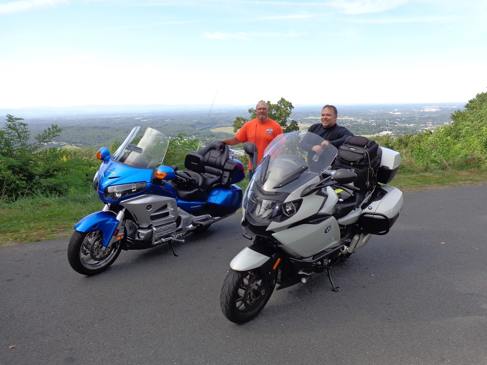
My friend Joe has been following my adventures since they started.  He's always looking for an opportunity to join in the fun.  Well, it worked out this time.  The plan was to meet him in Camp Hil PA and ride down to the beginning of Skyline Drive, a national parkway through the Sheandoah mountains.  During the planning stages, we invited my friend Mike to also join us, since this is virtually in his backyard and he's a Goldwing rider.  Joe is a new Goldwing rider, and boy does he have a pretty ride.

The plan was to avoid as much of Harrisburg's Friday morning commute as possible, so we met at Friendly's just off the intersection of 581 and 15.  I pulled in first and Joe had sent me a message that he was running behind.  Since it was already 11 and the kitchen was closing out breakfast, I ordered so I could have breakfast.  As usual, I left the house without eating.  This is a common theme.  There was no mistaking Joe pulling in on a very pretty blue Goldwing.  We caught up as had a hamburger and got on our way.

Since Mike couldn't join us, we decided to plow right into Skyline Drive instead of spending the night and doing Skyline on Saturday.  This was really good for me as I had to be at work on Monday and I really didn't want to a thousand miles on Sunday.  It's not the distance that bothers me, it's the lack of contingency time.  Traveling with Joe was awesome.  He'd never been up on Skyline and was absolutely amazed at the landscape and the scenic overlooks.  I encouraged Joe to stop as much as he wanted to, take pictures, etc.  The view from Skyline Drive is truly remarkable.  I'm hopeful that Joe goes back and takes Mary with him.  There is other good riding in that area, like Rt. 50 from Clarksburg WV to Winchester Va.  That also affords some spectacular riding and scenery.  I don't recommend that route when 2 up, unless your passenger is really into curves.

Our plan was to start looking for a place to stay as we neared 7pm and we started as planned.  As usual, and despite what the park sign said, there were no vacancies on the mountain.  One thing that I've learned in all the riding I've done is that no matter how tempting it is to ride to a town on the map, it's always better to ride toward interstate.  Towns may not have any accommodations, or for that matter food; whereas, interstates generally do.  In the US, and particularly on the East Coast, you can almost always find a place to stay, gas up and eat within 10 miles once joining the interstate.  Here, the tempting little town was probably about 5 miles closer than the interstate, and it was getting dark.  Both of us had a long riding day.  It was time to find something definite, not poke around.

We found a place to stay in Harrisonburg VA.  We weren't but a couple miles from the University.  We quickly dumped our gear in our hotel room and went off for a Mexican food dinner.  It was a fantastic day with fantastic sights and fantastic company.

The next morning, we ate breakfast and split up; Joe to go home and get some work around the house done and me to continue the ride back home.  Here's some pics.

**


About an hour or so off the exit, another K1600GT pulled up along side me.  It's rare to see another K16 rider.  There just are not that many of them out there.  This guy was riding with me for a very long time.  I was wondering about him.  He had what appeared to be a new bike; but, he had Wunderlich crash bars on the front and back.  Those are always aftermarket.  He had a paper NJ tag on the back and unfortunately, he didn't have a Bluetooth headset on.  I looked and I would have paired with him.  I was curious about his setup.  At some point, he motioned to me and asked me if I wanted to grab lunch.  It was lunch time; but, I was just about to split off and go East.  It worked out that he was also.  I agreed and we found a restaurant.

So, his story was that he got a great deal on this bike in NJ; so good in fact, that it was worth flying up there to get and ride back.  He was returning to Atlanta.  We decided to ride together to Columbia South Carolina, where he would split off.

Shortly after he split off and started heading to Atlanta, it started to rain.  There was a bridge ahead and I stopped very quickly to be able to put on rain gear under the bridge.  When I got back on the bike, I had an oil warning light.  This was disturbing.  I pulled into the next gas station and checked the oil.  It was bone dry.  I put in about 7 ounces to get a reading on the dipstick.  This was really disturbing.  I had the bike serviced 4,000 miles ago.  There should be no reason that I lost that much oil.  I recognized that there is a possibility that I'm not checking the oil properly.  This is a very complicated bike.  I also did not want to overfill on oil.

The rain storm was heavy.  People were pulling off the road and a South Carolina Trooper who was getting gas next to me said he recommended that I stay off the road for 15 minutes after the rain stops to let the standing water drain.  Good advice.

That night, I made it to Savannah Georgia.  I could have gone on; but, there were storms ahead and storms behind.  This was a good place to stop for the night.  When I got up in the morning, I checked the oil again.  It was bone dry again!  I added the rest of the quart and I still did not get a max reading on the dipstick.

When I got home, I inquired of my BMW MOA friends on FaceBook and they said there is a specific procedure for checking oil, do that.  I did and the reading was about the same.  The possibility that I can see is that when they did my 36,000 mile maintenance, they didn't fill the oil all the way.  Now, I'm paranoid about oil levels and check every ride.


Sunday, August 9, 2015

20150809 - Clarksburg WV to Alexandria VA (near Washington DC)

I made the right decision.  What an awesome ride.  By 8:30, the dew point / temperature spread was > 4 degrees F and opening fast.  The temp through the mountains was in the 70's, and I must say this was a fantastic ride.  I took US 50 all the way across WV and into VA, with only a brief 15 or 20 miles in Maryland.  I highly recommend it.  It is just as curvy as Tail of the Dragon, only the curves are spread out a little more, so you have time to calculate, learn from what you just did, apply it to the next curve and so on.  The speed limit on this route is 55 most of the way, except for the little jaunt into Maryland, where it comes down to 50.  There are also a couple small towns where the limit comes down to 40.  This is plenty fast on a rode that is riddled with 30 mph turns (real 30 mph turns - not just because they are posted that way).  I highly recommend this route for the riding and the scenery.  When you get into VA and pass Winchester on the way into the DC metro area, you will pass through many wonderful little towns.  Several are gathering places for motorcycle enthusiasts.

By now, my reader is wondering why I haven't published my composit map of my BMW K1600 travels, so here it is:


Now, one might be inclined to point out that OK and AR don't have any lines through them and I just declared victory on having ridden in all lower 48 states.  This would be because these states were ridden on my Harley.  The goal was to ride all 50 states.  To make it specific to my K16 would be very hard, considering Hawaii.

Here's some pictures from this trip.

 The obligatory photo of the Tree of shame.

 BMW riders and Harley rides can get along.  I made room for these guys.  We all shared great stories.


NO, I can't take off my helmet for selfie.  I have ear plugs in.  I'm not going to go through the trouble.  Maybe I could have put up my visors though.

Saturday, August 8, 2015

20150808 - Corbin KY to Clarksburg WV (and on to Washington DC area)

At this point, I have plenty of time to get to my destination before training begins in Tyson's Corner Va on Monday, so I'm going to stretch my ride a little and see more of KY and ride US 50 across WV.  The stretch of 50 that goes between Clarksburg and I-81 outside Winchester VA is very nice stretch of road that winds it's way through the Appalachians.

Ride, ride, ride, ride.  Kentucky is beautiful.  I'd love to buy a home out here.  Winchester is gorgeous and has some really nice houses.

When I got as far as Parkersburg, WV, it was time to check weather.  The skies were looking very soggy and if there are storms on the mountain, I don't want to be up there.  There are no places to hunker down.  Once this ride starts, you have only two choices - forward and back.  It's 3 and a half hours in duration.  It so happened that there was some light precip on the mountain and one thunderhead.  It was afternoon, when thunderstorms tend to grow.  I have about 5 hours between me and my destination and the option of picking up the interstate in Clarksburg if the weather guessers are wrong about tomorrow's weather.  I decided that I would go as far as Clarksburg - another hour East and check again.  This is the last point before I get into the mountains.

At Clarksburg, the weather looked about the same, maybe a little worse, so I decided to pack it in for the night.

20150807 - Cordele GA to Tail of the Dragon then to Corbin KY (then to Washington DC)

My lazy butt stayed in bed until 7:23am.  One would think that the excitement of doing the Tail of the Dragon again and scratching Kentucky off my list of states I haven't visited on a motorcycle would have had me out of bed; but, it didn't.  As per normal procedure, I checked weather and confirmed my routing.  The plan was to go around Atlanta and to check out some of GA's back country, so I routed through Athens and then up to Robbinsville - the town closest to the beginning of the Southern entrance to the Dragon.

Road kill has a much more pungent smell to it in Georgia.  I don't know what they season it with; but, it is different from road kill everywhere else in the country.  The other thing of note is the very distinct smell of trash in Georgia.  It felt like I was following a garbage truck for miles.  Maybe I was.

For the one or two people that are reading my blog, I have to mention that 129N and 411N south of Tail of the Dragon are not to be ignored.  These are great warmups for the Tail.  As luck would have it, it was drizzling leading up to the Tail and the Tail was wet when I got to it.  That didn't seem to slow me down at all.  For those detail oriented riders, I'm running Michelin Road Pilots (3 up front and a 4 in the rear).


The Tail is like Thanksgiving Dinner - lots of time thinking about it, maybe even planning for it; and then, it's all over in like 15 minutes or so.

After the Tail, I continued on and decided a good place to stop was Corbin KY.  I could keep going; but, this stopping point gave me some good options and I didn't have a plan after I got to KY anyway.  So, hotel it, charge everything, gas the bike and look at a map.  That's the plan.

20150806 - Spring Hill Fl - Cordele GA (then on to Washington D.C.)

First, my apologies for not having blogged in a long time.  Whoever you are that reads my blog, I appreciate it and I'm sorry if I let you down.  Statistics show that you, a single individual (or maybe two) consistently read my blog entries as I post them.  Someday, I hope to have a readership of 3 and I know I won't get there if I continue to treat my readership this way.  I humbly apologize.

I rarely have an uneventful trip and this first part of my journey is no exception.  Since I never plan and always procrastinate when possible, I found myself at the end of the work day wanting to leave, without anything packed.  The usual follies ensued - where's my umptyfratz charger, for that matter, where's my umptyfrats.  The funny thing is that I could care less about clothes as long as I have the right electronic gear, chargers and credit cards.  My closets are evidence of me having had to buy articles of clothing on many trips.  I digress.  Fortunately, I've done the motorcycle travel thing many times, so I know just what to pack and how to pack it.  This trip was going to be particularly exciting because there is no need to take heated gear with me.  I tend to pack light on the motorcycle and I like to make sure the bag I strap to the seat is full, as it serves as a back rest.  On this trip, there is almost nothing in the hard side cases - not the best for center of gravity; but, with this bike, the CG is plenty high to begin with.  I'm packed.  I leave.  It's 5:30 and I'm impressed because I stopped work at 5 sharp and managed to also clean the kitchen.

Starting this journey wasn't as fun as many.  There are so many things to worry about now.  I'm a supposedly responsible fish owner, I have a house now and I have grass that grows.  There's also a pool that needs chlorine and on and on.  It didn't take long and I was into my ride.  It's funny how I navigate very long trips without ever picking up a map or using the GPS.  The route was to be I 75 all the way to Atlanta.  I really had my hopes set  on making Atlanta, even though it would be midnight.  Friday morning traffic is horrendous and I'd like to avoid that.

Atlanta was a destination too far.  Mother nature is always in control and she thought it would be best for me to stop on Cordele GA; but, not before explaining to me in a gentle way (heavy rain with lightning) that going on was going be comfortable.  I tried to get into this little inn where I pulled off; but, the entrance was dug up and they were clearly under construction.  I needed to turn around and drive another 7 miles to a hotel.  The interesting feature about this hotel was the air conditioner.  Almost everywhere in the world, there are numbers between 57 and 71; in fact, there are an infinite number of numbers between 57 and 71. This is not the case in Cordele GA. In Cordele, there are no numbers between 57 and 71. The air HVAC in my room went straight from 57 to 71. Clearly, whoever did this was brought up on Common Core and using safe numbers or something.

Of interest on this trip was getting hit in the helmet by a fruit bat at 75 mph.   In the Universe of things, a tasty mosquito and 1,000 pounds of motorcycle and rider are not much different until you zoom in a bit. So it's quite understandable that a bat can fly into my helmet. If his radar wasn't jacked up before he hit me, it certainly is now...or maybe it's be knocked into alignment now.  At this point, the carnage I've left behind in my years of motorcycle riding is 2 birds, a groundhog and a bat.


Sunday, May 3, 2015

20150501 - Florida Panhandle

Excuses first. While I've been in Florida, I've been searching for a house.  It's occupied a lot of my time.  Riding, unfortunately has suffered and I haven't done nearly as many long distance trips.  That said, I have done a bunch of little ones.  For me to blog about a trip, it needs to  either be greater than 250 miles, or have some special significance.  The good news is that I'm supposed to close on a house on the 15th of this month and once I'm settled in, I should be back on the road.  It also looks like my contract might end in June, so I might be able to do the Alaska trip in July.  That would clearly make up for all riding sins.

So, on Thursday, I get a text message from Susie.  I haven't seen her since I'd say 2004, maybe 2003.  She is coming to Florida, Panama City Beach to be exact and then headed out to Louisiana I think.  I have other friends Tom and Charity who live in the area and thought it would be fun for all of us to get together.  As if I need an excuse to get on the bike and ride, and with my home just waiting on the seller to close, off I went.

This is a no GPS needed kind of trip; down Little road, North on 19, West on 98 to Panama City.  The hardest part was going to be finding Susie.  Tom had a date and couldn't make dinner.  Charity is nowhere to be found.  Tom will meet us for breakfast.

The ride is fantastic.  Once you're out of the urban sprawl, things open up nicely and once you start going west, things get good quickly.  The turn west starts with open road and plenty of greenery.  The trees are plenty tall, so you can't see all that far; but, one thing is for sure, all that green is awesome, compared to the browns of the West.  Until I lived out West for awhile, I never realized how much I like green.  I digress.  Before too long, I started crossing a bunch of bridges and large expanses of water.  I really like this kind of riding, where there is water on all sides.  In fact, so far, this is the only ride, other than through the Keys where I've been able to ride over open water, or within sight of open water for such a long period of time.  The only other place where I think a ride like this is possible, east of the Mississippi might be in NE Florida, Rt. A1A, or the rest of the panhandle.  I haven't ridden those parts yet and am pretty sure the East coast doesn't feature rides like this.   Here's a 20 second sample.  I cut the audio out.  It's all loud wind noise!


So, I arrive in Panama City Beach and quickly learn that "Thunder Beach" is going on.  There are tens of thousands of bikes here, most of them Harley's or custom built choppers; all loud.  I also saw, for the first time a Suzuki R1300.  It's long and has a very low height.  It looks like it would take a football field to turn around in.

So, I manage to find a room, which I think was probably a minor miracle given all these bikers.  Parking is between two buildings and is for motorcycles only.  I was clearly out numbered by the Harley crowd.   Fortunately, I think everyone was tucked in fairly early last night.  I heard a few bikes come and go; but, by 5am, engines were starting and I was quickly awake.

Before retiring for the evening, I had dinner with Susie and her brother Billy at  Saltwater Grill.  Of course, I Yelped for it.  It was rated well.  The food wasn't ok.  Nothing special.  For breakfast, the three of us joined our friend Tom.   Tom, Susie and I all worked for a the US Treasury as contractors once upon a time.  It was great getting together with folks I hadn't seen in over 10 years!

As of this moment, the map of places I've ridden on the K1600GT  looks like this.  I think I need to close the gap between Panama City Beach and Mobile, just on the account of because.  That, however will happen once I'm going to go out west.  From my house, all points West include 10 across the panhandle.  There's no need to go it now.


Saturday, March 14, 2015

Garmin Basecamp Review

My Configuration

I'm running OS X Yosemite on an 11" MacBook Air and BaseCamp 4.4.5, which is the latest at the time of this writing.   My GPS is a Garmin Nav IV that came with my K1600GT.

What I Tested

Basecamp seems like it has a lot of capabilities and over time I'll test more of them; but, this test was to create and ride a 100 mile loop near my house.  For this test, I needed to load BaseCamp on my computer, update my maps and software, plot the route, download the route and ride it with all the expected voice and visual queues I'd expect if riding a route created right on the GPS.  Along the way, I downloaded and reviewed previous routes I've been on.  This worked exceptionally well and was easy.

What I Didn't Test 

BaseCamp is pretty feature rich.  You can create a long distance trip over multiple days, add way points, search for lodging and eateries in the area where you will stop each night, etc.  I only looked at this briefly and found that it wasn't intuitive, so I bailed on it for now, for a simpler test.  I will probably write more about the trip functionality once I understand it better.

Installation

Installation was a breeze.  Download, next, next, accept, next, next, OK, next, bingo...or something resembling that. 

Once the clickfest ended, I opened BaseCamp and immediately got a notification that my GPS wasn't connected.  Well, it was in fact, still in the cradle on my bike.  It took me about half an hour to figure out how to get it out of my K1600GT.  It's never been out before.  If you're riding a K16 and have no clue, raise the windshield, press the button to the left of the screen, reach under the unit and make sure it is as high up as possible, find the lever behind the top right of the unit to release it from the cradle, tilt it forward and pull it out.

So, now I'm in BaseCamp, with my GPS attached and want to update my software and maps.  You can't do that in BaseCamp.  For that, you need to download and install Garmin Express using the same clicking procedure as is standard with darn near every piece of software you get these days (outlined above).  Once in, I tried to do the update; and was able to update the software; but, the maps wouldn't update all the way.  I called Garmin and they made me switch to the latest version of Express and then everything worked fine.  They led me through it and were really professional and helpful.  They get a gold star for support in my book.

Back to BaseCamp with a completely updated GPS.  Being a computer geek, I'm not one to read a manual or watch an instructional video.  I believe software needs to be intuitive, or they need to do a better job in the next release.  I would say BaseCamp is not intuitive.  I had to go watch videos on YouTube (Boo, :-( , etc.).  Finally, I started to understand how their interface works enough that I was able to create some routes.

Needs improvement

The Interface is Clunky.  It's not that you need a degree in Computer Science to operate it (I have one), it's that it's not intuitive.  As an example, when you use Google Maps and want to change your route, you just drag one section to the place you want to go.  It's simple.  You can also just type your way points right into the interface.  So, if you want to go from Miami Florida to Seattle Washington by way of Atlanta Georgia, Memphis Tenn, Denver Colorado, Yosemite National Park and Boise Idaho, you just type that in and wham, you have a route that you can simply adjust.  I haven't figured out any way to just do that yet - not intuitive.

Another problem with the interface is that you're constantly selecting tools, kind of like when you're using photo editing software.  You have choices between zoom tool, pan tool, pointer, etc.  You either use the right tool, or you get to do it again.  I think better use of the mouse/track pad is in order here.

Particularly distressing is the ability to zoom on the fly.  Say you're going on a trip from the acquarium in Tampa Florida to your favorite bistro in Atlanta Georgia.  You zoom all the way in on Tampa, find the acquarium, switch to the route tool, click on the acquarium.  Now, you're zoomed in so tight, there's no way you will see Atlanta, or for that matter anything further than a couple blocks from the aquarium, so you figure out that you have to use the + and - keys to control zoom, get the picture big enough that you can now see Atalanta, but, now what?  You can see Atalanta and Tampa in the same screen; but, forget about using your zoom tool to zoom in on Atlanta because you will zoom right back in on Tampa.  Remember, you're still in your routing tool, so clicking on the map will reorient your zoom; but, also plot a route to that point.  What I had to do was exactly that - drop a point on the route over Atlanta and then start to zoom in on my point.  Say the point is on the Northwest of city center and when you zoom in, you realize that you dropped your point Southwest.  I just hit control Z, and then clicked on a point closer to my destination and repeated until I had it right where I wanted it.  I'd say that's pretty clunky and I hope that after I watch a couple more hours of video, I'll find there's a better way.  As a sidebar, the videos were produced by some marketing guy, I'm sure of it.  I don't need to be sold.  I already have the product.  Explain it to me, don't sell it to me.  I digress.

The third nasty surprise is moving a point on a route.  Back to our example with Google Maps...  Got a route and want to bend it to another highway?  No problem, grab it and drag it.  Done.  Not so much with this interface.  I think you hold the option key and then click.  When you do, you get these crazy vector cross hair kind of things that make you think you're about to vector a missile into outer space or something.  It clearly makes you think you believe you learned something about this in sophomore year geometry; but, you forgot it.  Either way, you have to drag a point before the intersection of the part of the route you want to move or it won't work the way you expect.  Wait!  I think it's the other way around.  You may have to grab a point of the leg after the intersection...  See what I mean?  It's a disaster.  I haven't moved very many points this way at all.  It should be intuitive and it's not.  I'll watch more instructional videos.

Worked Well

Clearly, I can (with a little work) make my own routes and upload them.  I can also download previous routes.  Having this much control over my routing is outstanding.  Up until now, the only controls I really had were shortest vs. fastest route plus avoidances (traffic, highway, toll, ferry, etc.).  This is a major step up.  I can also share my routes with other people.  So, if I happen to find the most awesome-est route through Yosemite National Park, I can download it, send it to a friend, who can upload it into their GPS and ride it.  This is a really awesome capability.

I tried hard to make BaseCamp take a route that violated my preferences.  It wouldn't do it.  I said no highways and Garmin carved that into stone.  When part of my route would have been faster and shorter by using the highway, Garmin stuck to it's...software code (since it doesn't have guns) and routed me according to my preferences.  No matter what I did to try to trick it into taking the highway, it wouldn't.

I liked that Garmin requires you to plug in your GPS.  I know they do it for licensing reasons; but, by making you do that, you're guaranteed not to get a route out of BaseCamp that you can't ride because your map isn't up to date.  I see this as a plus.  I also see it as a plus because as as long as you're plugged into a laptop with an Internet connection, you can update your map.

Riding the route, my GPS prompted me just as I expected.  In fact, I was a little careless in clicking my route points and in one case, I actually clicked on the airport, about a quarter mile from the intersection, so the GPS tried to take me there.  The good news is that when I ignored the point and stayed on the rest of the route, it didn't try to recalculate my route back to the point I missed.

The Final Word

Quality software needs to do 4 things in my mind:  1)  It needs to install without any issues.  2)  It needs to function as intended.  3)  The user interface/experience must be exceptional.  4)  It must be secure.  Now, security isn't really a factor for this review, so  I give it 100% for Install, 100% for Function (in fact, there is very cool functionality I haven't tested yet) and I give it 50% for user interface / experience, for 250 of 300 possible points, or a grade of 82.5% or B-.  In my opinion, Garmin can add a thousand other functional components; but, until they make the user interface / experience better, they will never earn an A.