Weather decisions made easy - Should I leave tonight and get as far as Phoenix, or should I leave in the morning; either way, trying to make Fort Stockton Texas by Saturday night?
The answer is in this one weather map:
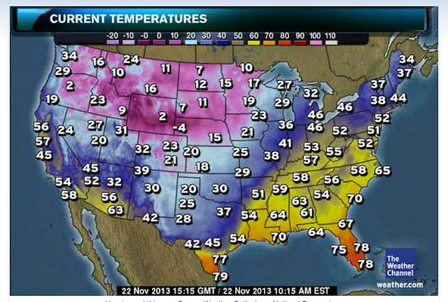
This map will stay mostly the same through Sunday, except that the 28 you see in Midland Texas will start creeping south. That said, my route from New Mexico through San Antonio is in jeopardy, with icy roads possible.
So, It seems like a better plan to attack that area of the country during daylite when the highest temps are possible. That means leaving tonight and pushing as far East as possible; Phoenix is good, Tuscon is better. With any luck, I won't have rain and freezing temperatures at the same time in Texas. Once I get through West Texas, it appears that I'll have dry roads; but, the 50's and 60's you see in this map turn to 20's and 30's. I can deal with that.
Even if I have to wait for a weather window, I'm better off doing it closer to the problem than in California, where it will take me hours to reach the area in question.
Into the rain I go!
You can watch my progress here:
http://share.findmespot.com/shared/faces/viewspots.jsp?glId=0Nh80LLnaj95s6rkXyLROojXqIlkmh6jn
…
I'm 575 miles into this trip now. It's been rain pretty much the entire time. I got a phone call from a good friend of mine and he kept me talking for an hour enabling me to make Lordsburg, New Mexico. When I came through Tuscon, they said don't go up on the mountain. Well, I didn't listen to the locals. Everything was calm until I got to about 4,000', then all hell broke loose. It's not raining as much as it was earlier today and it's not cold - 43 degrees. It's WINDY. Winds are blowing ESE 31 with gusts to 40-45. I was holding 0-15 degrees of lean most of the way up the mountain and I think my tires will have uneven wear on the right side. The sound of the wind sounds like a freight train going through my helmet.
I plan to get up at 6 and check the weather. If it's above freezing I plan to move on. If I make it to San Antonio, I should be in good shape for the rest of the trip. If I don't, I may be stranded in Texas until this storm passes through.
Wish me luck!
…
Now that I have some downtime, I can write a little more. It seems that California was doing it's best to make sure I stayed. Yesterday, nothing seemed to be working out. The forecast was horrible for the weekend and CA was rainy and windy. Never a good start to a trip. When I got home from work to pack, I parked outside my apartment like I normally do. It's on an incline and the bike stands pretty straight up because of that. Well, yesterday, I got no more than 20' from my bike and a gust of wind took it right over. I have damage (scratches and gouges only) to the right side of the bike. It went over hard. I'll post pictures. Fortunately, no mechanical damage.
I was telling my friend Jeff, who has been really great in keeping in touch with me this ride, about it and he thought a new paint job in the form of a shark with aggressive teeth would look good. Since my bike already has a natural transformers type look to it, I have no doubt I could incorporate both.
Something to think about; who's got a BMW K1600GT that looks like a high tech shark? It's a pretty awesome thought?
Jeff, Chris, Dad - Thank you all for keeping me company on this trip. It makes the miles go by very fast.
Henceforward this blog will etch into history my adventures on the BMW K 1600 GT - people, places, calamities, happenstance and all joyous occasions. Read on about my journeys, maintenance, equipment reviews and more.
Friday, November 22, 2013
Wednesday, November 20, 2013
11/20/2013 Paul ties a gremlin bell on my ride
Today, my friend Paul, who I've done 2 long distance trips with tied a gremlin bell on my ride. Paul is a very skilled rider who has probably ridden a couple million miles in his day. He knows how to drive; but, he chooses his BMW LT 1200 over a car every time. So, it's an honor to have Paul tie my bell on. If you don't know the story, here it is, cut from the pages of www.gremlinbells.com.
<<<snip>>>
Have
you noticed that some riders have a small bell hanging off their motorcycle
frame or handlebars?
Have you wondered what the purpose is? That little bell is more than decoration, it serves a very important
purpose – it wards off gremlins, also known as evil road spirits.
You see, there are motorcycle gremlins that LOVE to ride, but they are also mischievous little devils and they cause all sorts of problems for you while you are riding. Some say they are responsible for that old lady in the minivan not seeing you and cutting you off in traffic. Or, you may be having trouble shifting smoothly, your battery goes dead, your turn signal suddenly refuses to work, an oil spill appears out of nowhere, you hit a patch of black ice, etc – you get the idea. Those little gremlins look for trouble and try to steer your bike towards it.Now, once you get a bell on your scoot – it wards off these attacks from the little gremlins, not allowing any more to get onto your bike. If you already have some gremlins riding with you, they will get trapped in the hollow of the bell, and the constant ringing will drive them insane – causing them to lose their grip and fall to the roadway.Do you have the protection of a gremlin bell?
<<<snip>>>
Sunday, November 17, 2013
11/22 - 11/25 CA to PA Planning
I have settled on a plan to get from California to Pennsylvania. The route I want to take is just better than 3,000 miles, and if I can do it in 72 hours, I will get another Iron Butt certification. Here's the mileage table…
The actual trip is about 3100 miles. On the last leg, I'll either stop before my destination to get my affidavit signed, or, if I can make it within the timeframe, get it signed at my final destination.
The good news is that this gets me to my destination during daylight. This is important because there is the possibility of snow and ice. I'd like to be off the road on my final day before the sun is down. This plan makes it possible; but doesn't give me much contingency time. Whatever contingency time I do get will be from traveling more than 60 miles per hour and sleeping less than 8 hours a day. This route also keeps me in the South, where it's warmer, for as long as possible.
Game on!!!
The actual trip is about 3100 miles. On the last leg, I'll either stop before my destination to get my affidavit signed, or, if I can make it within the timeframe, get it signed at my final destination.
The good news is that this gets me to my destination during daylight. This is important because there is the possibility of snow and ice. I'd like to be off the road on my final day before the sun is down. This plan makes it possible; but doesn't give me much contingency time. Whatever contingency time I do get will be from traveling more than 60 miles per hour and sleeping less than 8 hours a day. This route also keeps me in the South, where it's warmer, for as long as possible.
Game on!!!
Saturday, November 16, 2013
11/16/2013 - Yosemite (Pictures)
6 AM local time and of course, I'm wide awake. It's 29 degrees outside, with a high forecast of 55. Wind will pick up in the afternoon to 11 MPH; but, for the morning, they are going to be pretty tame, so wind chill should be pretty tame. We're only going to cover 200 and some miles, so we're planning lots of stops to photograph the fire damage and the beautiful areas of the park. Tonight's stop will be in Bakersfield, making for a pretty short ride home on Sunday.
My spot failed me a little today. We didn't really go from point 47 to point 48 on this map in 10 minutes. Actual time was about 2 hours. I think the tree canopy may have stopped Spot from talking to the satellite. Also, we started at point 30 today. Here's a better map of today's travels…
Rt. 49 out of Mariposa is outstanding. The road is new blacktop, newly lined, with a very consistent surface. I don't think we experienced a single bump the entire time. The curves are fantastic; though, many of them are blind and require lots of attention to your speed and line.
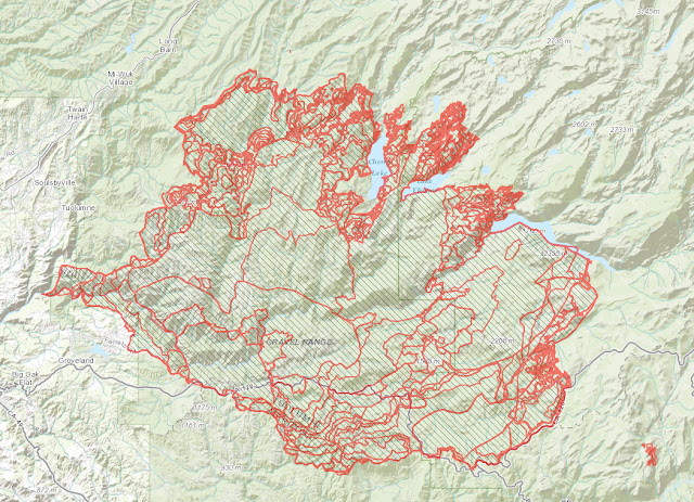
Our first stop in the park was at some fire damaged areas. It's unsettling and pictures can't describe how bad it is. Here's a map of the fire damaged areas…
I don't have any sponsors; but my friend Paul works for ESRI, a Geographic Information Services (GIS) company. He made this map using their arcgis web tool. www.arcgis.com This is the same tool that the firefighters were using and populating data into. During this fire, firefighters were flying over this fire collecting data, infrared and otherwise, and populating this tool. Behind this map and each little perimeter is a series of data. You can click through this map on arcgis server and see all that data. It's an incredibly powerful tool. Thanks Paul for taking the time to show me all this.
If you happened to be asleep in July, when the fire started, here's what you missed…
And finally, some of today's pictures…
My spot failed me a little today. We didn't really go from point 47 to point 48 on this map in 10 minutes. Actual time was about 2 hours. I think the tree canopy may have stopped Spot from talking to the satellite. Also, we started at point 30 today. Here's a better map of today's travels…
Rt. 49 out of Mariposa is outstanding. The road is new blacktop, newly lined, with a very consistent surface. I don't think we experienced a single bump the entire time. The curves are fantastic; though, many of them are blind and require lots of attention to your speed and line.
Our first stop in the park was at some fire damaged areas. It's unsettling and pictures can't describe how bad it is. Here's a map of the fire damaged areas…
I don't have any sponsors; but my friend Paul works for ESRI, a Geographic Information Services (GIS) company. He made this map using their arcgis web tool. www.arcgis.com This is the same tool that the firefighters were using and populating data into. During this fire, firefighters were flying over this fire collecting data, infrared and otherwise, and populating this tool. Behind this map and each little perimeter is a series of data. You can click through this map on arcgis server and see all that data. It's an incredibly powerful tool. Thanks Paul for taking the time to show me all this.
If you happened to be asleep in July, when the fire started, here's what you missed…
And finally, some of today's pictures…
Thursday, November 14, 2013
20131115 - Yosemite
Tomorrow, I'm leaving for Yosemite with a friend from my customer site. We plan a departure at 4pm and will stay outside of Yosemite tomorrow evening, and close to Barstow on Saturday evening.
The weather for the weekend is predicted to be clear with temps between 27 and 60 degrees.
--------
Here's the route we took this evening. We started at 4:15 and pulled into our destination 11:30pm. We stopped for about 30 minutes and got tied up in LA traffic (70 minute delay) while an 18 wheeler burned on the side of the road.
The weather for the weekend is predicted to be clear with temps between 27 and 60 degrees.
--------
Here's the route we took this evening. We started at 4:15 and pulled into our destination 11:30pm. We stopped for about 30 minutes and got tied up in LA traffic (70 minute delay) while an 18 wheeler burned on the side of the road.
Wednesday, November 13, 2013
R1200RT Ride report
It seems like yesterday that I was bringing my K1600GT in for it's 6,000 mile service; in fact, it was exactly 3 months ago. BMW is great about providing a loaner bike, even if you're only going to be there an hour. BMW of Riverside California is an outstanding dealership and today was no different. I asked if I could take an R1200GS as a loaner while my K16 was in for it's 12K service. One trip out to the sales floor and Owen, the sales manager, had me riding out on a 10 day old R1200GS. He asked if I could please put 100 miles or more on it. He currently has that bike in as a demo and until it gets 15K on it, he can't sell it. He got 8 of these in last week and sold them all. Game on, I'm happy to help. In fact, if you need this kind of help in the future, I'll be happy to stop by and ride whatever you have. There's not a bad ride in the store. I digress.
The R1200GS is a dual sport bike. It's able to go between dirt and pavement. It's the kind of bike that you can use when you're camping off road and want to roll right up to your tent; followed by a day of punishing off road excitement. You can also go do some serious long distance riding, provided you added some amenities. You can equip this bike with various size panniers and top boxes. It is a very light and well balanced machine. The bike is known as a "water boxer," for it's characteristic placement of the cylinders and the fact that it's water cooled.
Aside from the very formidable stance at the curb, one of the first things I noted was the sound of the engine. It sounds very European. I can easily imagine myself on the back of one, chasing Arnold Schwarzenegger down the slopes in True Lies; Uzi slung over my shoulder, studs in the tires…you get the picture.
Being a K1600GT rider, there were some very obvious differences; the first being wind protection. 64 degrees on the back of this is colder than 64 degrees on the back of the K16. The wind screen offers some wind protection; but, nothing in comparison to what the K16 provides. That said, I wasn't uncomfortable at all. The wind hits the wind screen and goes right over my head. Wind noise is fairly loud, as is the sound of the engine…again, in comparison to the K16. I was happy to see that the bike had a cruise control. There is also some click through instrumentation; but, many of the amenities of the K16 are not on this bike; nor should they be. The suspension is very comfortable. I rode standing up and bounced on the pegs to feel how much shock absorption there is. I was impressed.
I think that if I were to buy one, the first thing I would do is change out the seat with a Rick Meyer saddle. Actually, the first thing I would do is install a crash bar frame. I'm sure that if the bike goes over, those jugs are toast. I'm really surprised the bike doesn't come with them. After that, I think I'd add in the GPS and if I could get bluetooth XM satellite and weather, I would do that. Of course, big panniers are a necessity. I don't know if the bike comes with them or not.
There was nothing unimpressive about this bike. It has plenty of acceleration and stopping power. It's light and nimble. I think that if I were doing a very long distance trip - 2,000 miles or more, I'd want to do it over a longer period of time than say on the K16; but, the R12GS has the K16 beat when the pavement ends. I think this means that I will need to have both.
The R1200GS is a dual sport bike. It's able to go between dirt and pavement. It's the kind of bike that you can use when you're camping off road and want to roll right up to your tent; followed by a day of punishing off road excitement. You can also go do some serious long distance riding, provided you added some amenities. You can equip this bike with various size panniers and top boxes. It is a very light and well balanced machine. The bike is known as a "water boxer," for it's characteristic placement of the cylinders and the fact that it's water cooled.
Aside from the very formidable stance at the curb, one of the first things I noted was the sound of the engine. It sounds very European. I can easily imagine myself on the back of one, chasing Arnold Schwarzenegger down the slopes in True Lies; Uzi slung over my shoulder, studs in the tires…you get the picture.
Being a K1600GT rider, there were some very obvious differences; the first being wind protection. 64 degrees on the back of this is colder than 64 degrees on the back of the K16. The wind screen offers some wind protection; but, nothing in comparison to what the K16 provides. That said, I wasn't uncomfortable at all. The wind hits the wind screen and goes right over my head. Wind noise is fairly loud, as is the sound of the engine…again, in comparison to the K16. I was happy to see that the bike had a cruise control. There is also some click through instrumentation; but, many of the amenities of the K16 are not on this bike; nor should they be. The suspension is very comfortable. I rode standing up and bounced on the pegs to feel how much shock absorption there is. I was impressed.
I think that if I were to buy one, the first thing I would do is change out the seat with a Rick Meyer saddle. Actually, the first thing I would do is install a crash bar frame. I'm sure that if the bike goes over, those jugs are toast. I'm really surprised the bike doesn't come with them. After that, I think I'd add in the GPS and if I could get bluetooth XM satellite and weather, I would do that. Of course, big panniers are a necessity. I don't know if the bike comes with them or not.
There was nothing unimpressive about this bike. It has plenty of acceleration and stopping power. It's light and nimble. I think that if I were doing a very long distance trip - 2,000 miles or more, I'd want to do it over a longer period of time than say on the K16; but, the R12GS has the K16 beat when the pavement ends. I think this means that I will need to have both.
Sunday, November 10, 2013
11/09/2013 and11/10/2013 - Death Valley
As my time winds down in California, there are two must do trips left - Death Valley and Yosemite. There are more trips to take; but, as I go back East, I want to get these two, in case I never ride California again.
The plan was to leave Saturday morning, take a leisurely 5 hour ride up to Death Valley, camp, ride the park in the morning and come back on Sunday. Weather? It's Death Valley in November. I'm expecting temps between 40 and 80 and no precip whatsoever. A quick look at the forecast showed I was right. I got home later than expected on Saturday mooring, packed my stuff and was on the road in no time.
The route took me up 215 to 395. I've ridden 395 before and I like it. It's a fast road with lots to look at. When I got to the turn off for 178, I was confronted with a sign indicating the road was closed 52 miles ahead. I decided to continue North and let the GPS re-route me. About 5 miles up 395, I grabbed the next road headed to Death Valley - Searles Station Rd.. About 5 miles down the road, I waved to two guys standing by a quad on the edge of the road. One of them looked like he was signaling vs. waving, so I swung a u-turn and came back around. It works out that they had 2 quads, one of which was stuck about 1/4 mile from where they were standing. They needed to tighten the chain and didn't have tools. My adjustable wrench and screwdriver would work just fine. In trade, Carl and Doug offered some nice cold offer from their cooler. Doug took the tools and rode off. I waited with Carl, sipping a nice cold bottle of water in the desert. Carl told me that the road I was on would hook me right back up to where the detour was. I pulled out my road atlas and found out that 45 miles up 395, 190 began and that would take me right into Death Valley. Doug came back about 10 minutes later, quad fixed. I put my tools away and started off on my new route.
At this point, I was going to get to the entrance of Death Valley about 5. That's plenty of time to pitch a tent before dark, in theory. In actuality, the entrance to the park is about 50 miles from the nearest camp ground. In addition, Death Valley is in a bowl. The sun drops behind the mountains about 4:30. It wasn't looking good for a daylight pitch.
When I pulled in, the sun was still up; but, just barely. I needed to pitch my bivvy tent partially in the daylight; but, mostly in the dark. Whoever said that they can setup camp in 10 minutes is smoking something. I'm not slow by any stretch; but, it was probably 30 minutes before I was ready to slide in if I wanted to. For my guy wires, I was using para-cord with figure 9's. These are really quick and easy to tension. I highly recommend these. The campground was Stovepipe Wells and I understand the next campground, Furnace Creek was sold out. I got the last tent site and unfortunately, was on the site right next to a bunch of fans. I got lucky! Lately, it seems to be the case that no matter where I go, there's some kind of convention. Saturday night was no different. Who knew there were so many "Death Vally 49'ers?" There are lots. They had already stolen my table. I didn't care, I couldn't use it anyway. I wasn't bringing food to the campground. The table theives were nice enough to hold a flashlight for me while I pitched - even though I had two of my own.
After getting set up, the plan was to get some food and head back to the tent. There was no rush since there was no electricity or Internet at the camp site. When I got back to the tent, it was dark, and the temperature was going down like an out of control bobsled. The good news is that inside my tent was about 10 degrees warmer than the outside air. I stayed up for awhile playing free cell and listening to my drunk neighbors share completely embellished stories of various things they've done. Star watching from the tent was awesome. I pulled the tent fly back and had a great view. It's so dark and clear in Death Valley, there is nothing to obstruct the incredible star show. After awhile, I gave up trying to stay up, shut the tent and went to sleep.
I tend to use my sleeping bag as a comforter vs. a sleeping bag unless it gets pretty cool. And so it was, until about 4am when the temp had dropped into the 30's. I zipped myself in and was nice and comfortable the rest of the night. I was awake before the sun came up, so I decided to brave the cold, break camp, get some pictures and breakfast and start the day.
Right after the campgrounds were the sand dunes…
Stop number one on the Death Valley tour was Zabriskie Point. 500 photos or a video…I shot some video. But first, on the way, two stills that are both very interesting…
Next up, Dante's View - 23 miles away. We're going from sea level to 5475'. The climb is fast. One section is a 15% grade with switch backs. It's pretty exciting and you don't want to get caught in two high a gear, you won't make it. Here's some video of Dante's view
and one still with helmet head…
Stop number three was Artists Drive. This is an 8 mile loop that has traffic in 1 direction. It's mostly canyons and I decided I wanted more riding than sightseeing and decided to document the loop with GoPro.
After Artists Drive, I went to Badwater Basin. This would have to be my last stop so I could get back in time to do laundry and have clothes to wear at work. This would definitely be the lowest point I've ever been to on earth.
The sea level sign is 287' above. Shown in the foreground is my handlebar.
The plan was to leave Saturday morning, take a leisurely 5 hour ride up to Death Valley, camp, ride the park in the morning and come back on Sunday. Weather? It's Death Valley in November. I'm expecting temps between 40 and 80 and no precip whatsoever. A quick look at the forecast showed I was right. I got home later than expected on Saturday mooring, packed my stuff and was on the road in no time.
The route took me up 215 to 395. I've ridden 395 before and I like it. It's a fast road with lots to look at. When I got to the turn off for 178, I was confronted with a sign indicating the road was closed 52 miles ahead. I decided to continue North and let the GPS re-route me. About 5 miles up 395, I grabbed the next road headed to Death Valley - Searles Station Rd.. About 5 miles down the road, I waved to two guys standing by a quad on the edge of the road. One of them looked like he was signaling vs. waving, so I swung a u-turn and came back around. It works out that they had 2 quads, one of which was stuck about 1/4 mile from where they were standing. They needed to tighten the chain and didn't have tools. My adjustable wrench and screwdriver would work just fine. In trade, Carl and Doug offered some nice cold offer from their cooler. Doug took the tools and rode off. I waited with Carl, sipping a nice cold bottle of water in the desert. Carl told me that the road I was on would hook me right back up to where the detour was. I pulled out my road atlas and found out that 45 miles up 395, 190 began and that would take me right into Death Valley. Doug came back about 10 minutes later, quad fixed. I put my tools away and started off on my new route.
At this point, I was going to get to the entrance of Death Valley about 5. That's plenty of time to pitch a tent before dark, in theory. In actuality, the entrance to the park is about 50 miles from the nearest camp ground. In addition, Death Valley is in a bowl. The sun drops behind the mountains about 4:30. It wasn't looking good for a daylight pitch.
When I pulled in, the sun was still up; but, just barely. I needed to pitch my bivvy tent partially in the daylight; but, mostly in the dark. Whoever said that they can setup camp in 10 minutes is smoking something. I'm not slow by any stretch; but, it was probably 30 minutes before I was ready to slide in if I wanted to. For my guy wires, I was using para-cord with figure 9's. These are really quick and easy to tension. I highly recommend these. The campground was Stovepipe Wells and I understand the next campground, Furnace Creek was sold out. I got the last tent site and unfortunately, was on the site right next to a bunch of fans. I got lucky! Lately, it seems to be the case that no matter where I go, there's some kind of convention. Saturday night was no different. Who knew there were so many "Death Vally 49'ers?" There are lots. They had already stolen my table. I didn't care, I couldn't use it anyway. I wasn't bringing food to the campground. The table theives were nice enough to hold a flashlight for me while I pitched - even though I had two of my own.
After getting set up, the plan was to get some food and head back to the tent. There was no rush since there was no electricity or Internet at the camp site. When I got back to the tent, it was dark, and the temperature was going down like an out of control bobsled. The good news is that inside my tent was about 10 degrees warmer than the outside air. I stayed up for awhile playing free cell and listening to my drunk neighbors share completely embellished stories of various things they've done. Star watching from the tent was awesome. I pulled the tent fly back and had a great view. It's so dark and clear in Death Valley, there is nothing to obstruct the incredible star show. After awhile, I gave up trying to stay up, shut the tent and went to sleep.
I tend to use my sleeping bag as a comforter vs. a sleeping bag unless it gets pretty cool. And so it was, until about 4am when the temp had dropped into the 30's. I zipped myself in and was nice and comfortable the rest of the night. I was awake before the sun came up, so I decided to brave the cold, break camp, get some pictures and breakfast and start the day.
Right after the campgrounds were the sand dunes…
Stop number one on the Death Valley tour was Zabriskie Point. 500 photos or a video…I shot some video. But first, on the way, two stills that are both very interesting…
Next up, Dante's View - 23 miles away. We're going from sea level to 5475'. The climb is fast. One section is a 15% grade with switch backs. It's pretty exciting and you don't want to get caught in two high a gear, you won't make it. Here's some video of Dante's view
and one still with helmet head…
Stop number three was Artists Drive. This is an 8 mile loop that has traffic in 1 direction. It's mostly canyons and I decided I wanted more riding than sightseeing and decided to document the loop with GoPro.
After Artists Drive, I went to Badwater Basin. This would have to be my last stop so I could get back in time to do laundry and have clothes to wear at work. This would definitely be the lowest point I've ever been to on earth.
The sea level sign is 287' above. Shown in the foreground is my handlebar.
Subscribe to:
Posts (Atom)