I have Garmin BaseCamp, a not all that intuitive mapping tool. You can do route planning with this tool and download the plan (route or waypoints) to your GPS. My objective is to not use Interstates, Toll Roads. I prefer county roads over state highways. Basemaps allows me to make that happen. For the first time, I created a route and rode the route. When I found that I had more time on my hand than expected, I went exploring; but, for a large part, I rode the route I planned. There, I said it. I planned my ride. As you can see, I'm trying to get myself to accept that planning is OK. I've also found an API called overpass.turbo.eu that allows me to box an area on a map and query the map data about what's in that area. As an example, I can ask it to show me all the secondary, secondary_link, tertiary roads in the box. With this, some Python and BaseCamp, I can craft routes that I haven't been on, are off the beaten path and much more fun than riding on highways! I didn't know about this tool until after this route was planned (I said it again); but, I will use it in the future. My route partially used a track from a previous ride, so I already knew that I would be on some awesome roads!
So, the destination was Flemmings Prime Steak House in WinterPark (Orlando) and I was going to be meeting Craig Barrett, a friend who used to work with me on the Treasury Communication System. I planned to ride for 3 hours before getting there and then ride home for another hour and a half. We talked for 3 and a half hours. There was so much to catch up on - family stuff, work stuff, stuff stuff. It was a great time, the food was great and so was the riding! Going home, a dead racoon jumped out in front of me. It must have jumped out because it wasn't there before I saw it. I had enough time to decide to run it over as opposed to trying to steer around it. Steering around it would be dangerous. If I hit it on an angle, I would have a high probability of wrecking. This brings the number of dead animals that either hit me or I hit to 6 - 2 birds flew into me (one hit me square in the chest and one flew into my lower right leg); 1 bat (it glanced off the right side of my helmet); 1 snake (he didn't deserve to get run over; but, he was completely stretched across the lane when I came around a curve); one running ground hog and now, one dead racoon that magically appeared in my lane. Hopefully, there won't be more.
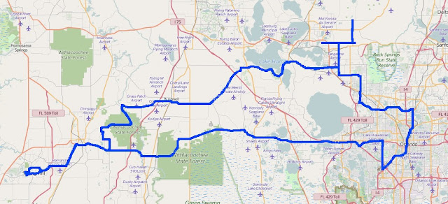
Here is the all important map of the route. I just realized I did not get a picture with Craig. I am now very bummed out.
No comments:
Post a Comment