Morning Post:
The original plan was to bring the bike back to the Northeast during this week to avoid winter storms. It just works out that winter storm Boreas started wreaking hell across the United States right when I was to depart. A flaw in my weather planning was looking at the route and not the National Weather Outlook. I saw the possibility of snow and ice along my route and hoped, that since it was Texas in November, it would be minimal, or a dusting. I was very wrong. The lesson learned here is to get as much information as possible, and in this case, that includes the national outlook. If I turned on the television once in awhile, I probably would have seen it; but, since I turn on a television once or twice a month, I missed it. There's another lesson, watch more TV...or at least the weather channel. And a final lesson is that you have to strike at opportunities as they appear. Had I stayed any later in New Mexico, this trip, I would have been buried in feet of snow. Likewise, had I stayed any longer in Sierra Blanca, I had a big risk of missing my arrival window before Boreas beats up the East Coast.
Patience and good decision making have gotten me this far. I'm 1/3 of the way complete with my journey and I should have been pulling in by 1pm tomorrow; but, it is what it is. My new arrival window is planned for Tuesday evening. I've also had to change my route. Now, I will take I-95 up the coast vs I-81. I-81 is a much better traffic option; but, I-95 should keep me East of the wintery mix. No matter what, my rain gear will be tested today and tomorrow.
Here's what I'm dealing with: <<<Click me>>>
The biggest question in my mind is what I do when I get to Mobile. I have a choice - either 85N to join 95 mid way up the coast, or continue into Jackson Fl. and take 95 the whole way. The later assures me that I will be far away from the storm; but, adds another 100 miles or so to the total trip. That 2 hours could be the difference between making NJ or not making NJ if the storm gets further East than predicted. If I take 85, I'll cut the two hours off; but, travel closer to the icing conditions for the whole route. I'm leaning toward the former option. The good news is that I can make my decision later today, or tonight.
Kickstand up at 8am.
...
Evening Post:
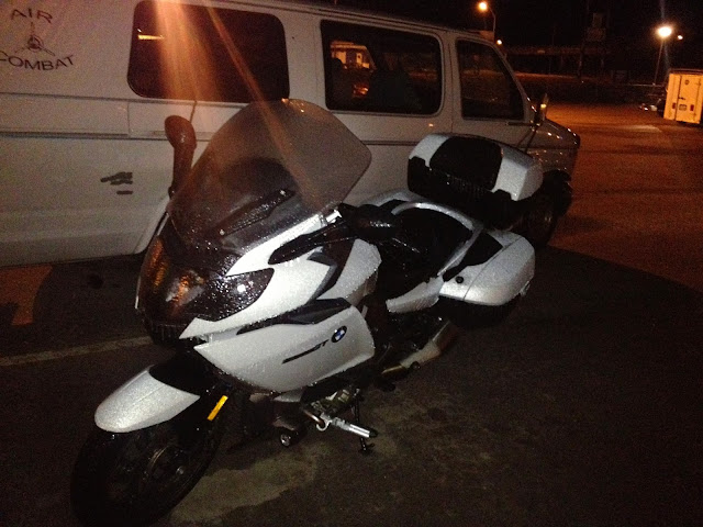
Well, here I am, Houston Texas, about 500 miles from my planned destination of Mobile Al. I am stopped for the night.
Ya know that sensation in your ear when you get out of the pool and have water stuck in there? Well, let me just say that you should never feel that sensation on a bike; pool, yes; SCUBA yes; motorcycle, no.
The day was going just fine. I braved the sleet and ice in the morning, cheating death for hours at a time, watching the temperature inch it's way up from 28 when I left to 35 by the time i got to San Antonio. By the way, there's a big difference between 30 and 32 and 28 and 30 degrees. In the later case, things might be frozen and bridges are. In the former, you're trying to find a path between piles of frozen stuff. I'm just sayin' Now that I've said it, I should probably go on record that I don't advise anyone to try either. Stuff that glistens on the road needs to be avoided at all costs and if you can't hold a line, hang up your helmet and try again when conditions are better. Temperature wise, I was a toasty warm. My Gerbings gear performs very well and often, I need to dial it back. The major issue on this trip has been visibility. At cold temperatures, my face shield fogs up, causing me to have to leave it cracked open a quarter inch and, when you have salt and road grime all over the wind screen, all that is useful for is for it's wind protection. In the rain, the face shield is fogged up worse and a quarter inch open does nothing. The good news is that the only evidence (except this blog) of the salt and road grim has been washed off by the pounding rain.
As has been the case this trip, I've been getting occasional phone calls. Today, my bro Dave called while I was in San Antonio, and I asked him to check the forecast for me. He said I was going to go through a band of rain that stretched from Corpus Christi into the mid-west and width wise, it was about half the distance from San Antonio to Houston. I asked what color rain Dave was seeing on the radar and he said dark green. I can deal with dark green rain, yellow and red are bad. So, I planned to get wet; but, didn't see any showstoppers. Onward ho! Just as I was nearing Houston, my mom called and we were discussing the fact that I was about to hit Houston during rush hour and how that wasn't good. We also talked about Dave's call and how dark green rain isn't so bad. Just then, traffic came from every direction and I had to end the call. Within minutes, it was pouring and the ride was getting challenging. First, my face shield was getting fogged up and my only option was to open it if I were to have any chance of seeing anything. I also needed to get the wind screen down as that was like trying to see though milk. After about 20 minutes of this, traffic nearly came to a standstill, where I sat, getting wet, barely inching along. I also noted that my left hand was wet inside my glove from my finger tips to the palm of my hand and that water had found it's way underneath my helmet and collar and was streaming down my back. Well, that wasn't enough to stop me. I kept going. By now, it was dark and I was getting concerned about the fact that I couldn't recognize the standing water any longer and was taking my queues from cars splashing through puddles. Right about then, the pickup truck in front of me went through about 20' or more of standing water that was about 3 or 4 inches high. I wasn't measuring; but, it came up about half way or more to my pegs. When he hit that puddle, water sprayed out from his truck to the left and the right to a height about 2' over his cab and drenched the car to his right. I had just enough time to grab a handful of clutch when I hit it.
Let me just say that motorcycles can forge through water. I know a motorcycle cop in PA who had riding in the Susquehanna as part of his qualification. He had to ride out to a bouy that put him in water up to his air cleaner, turn around and come back without dumping it.
So, what happened? Well, the bike abruptly slows down due to the increased drag on the tires. Water went into the air; but, wasn't as impressive as the truck in front of me. Water FLOWED across my boots up to about 2" higher than my ankles. I decided enough of this and decided that the Hampton Inn that I just passed was the place to be for the night. There was no way I wanted to risk this all the way to Mobile AL.
Fortunately, there was room at the Inn. As I pulled up, I admired my freshly bathed bike. It was still wet of course; but, it wasn't looking as horrible as it did when I got to San Antonio. So, how did my gear fair? Glad you asked.
Spot tracker - still working; but, drenched. +++++
Top case - Contents dry +++++
Side cases - Don't know. I haven't opened them.
Bag bungeed to the passenger seat - Some contents wet. The included rain fly did a lot to protect the bag; but, it was wet. The compression sack with my power cords in it was wet; but, the contents were also wrapped in a ziplock bag and were dry. My Jeans and sweatshirt were wet in spots. My hiking boots, which were on the bottom had wet laces. ++
Goretex rain jacket and pants - These performed very very well. If I were wearing the hood inside my helmet, I would not have gotten wet inside at all. +++++
Boot rain covers - These worked pretty well. I recommend them; but, since my boots and right sock got wet, they only get ++++ out of +++++. Then again, maybe I should give them more credit. After all, my feet were pretty much submerged. Fine I'll give them all 5. +++++
Heated Gerbings Leather gloves - Soaked all the way to the inside. These have nothing to keep rain out. They're fine in mist and light drizzle; but, are horrible in rain. I need outer rain gloves. They get 0 out of 5 +'s for rain protection. For heat though, they get all 5 +'s.
Schuberth helmet. I think what is needed is a nose cup to keep exhaled air off the face shield. Other than the visibility issue, I really like it. +++
So, now you know how I got water in my ears. That said, what now?
Well, it's become clear that winter storm Boreas is just ravaging the country and killing people in it's path. The death toll is up to 14 now. If I try to soldier on, I'll be riding in rain the whole way home and risk arriving in sleet/snow/ice. Since I've already done that and have the blog to prove it, I decided to park the bike and fly home for the holidays. Fortunately, it works out that my bro has a sis no more than 20 miles from here and she has space in her garage for as long as I need it. I will have to ride for about 40 minutes in pouring rain tomorrow morning; but, there is a clear path to Thanksgiving dinner now. Why not a U-Haul? Well, my bike hasn't been on a trailer yet. I'm not about to start a tradition of not finishing my rides. It's one thing if it's broken and can't be repaired roadside. It's another thing entirely to put a fine ride like mine on a trailer for any other reason. It's simply a pause in the journey.
Before I close out this show some video clips, I want to take a minute to say thank you to all my friends and family who have been following this trip with such curiosity and concern. I really appreciate all the phone calls, FB and blog comments. I want to especially thank my biker friends, who know the challenges of the open road and have followed me the whole time. Jeff, Joe, Dave, Paul, Mike, Scot, you're all top notch bikers and I take all your advice to heart. Susan and Gary, thank you for giving my bike shelter while I enjoy the holidays with family. You guys rock.
Now for some of today's best video's...
This first one will be instructional for some of my West Coast friends. Basically, when the temperature is lower than 38 degrees, you have to be concerned about ice. Yes, 32 is freezing; but, ice hides in shady corners and bridges get iced up faster because wind can pass above and below the road surface, as seen in this video. This video was shot at about 31 degrees, making anything wet suspect. Glistening stuff is to be avoided. It's probably ice. The idea is to hold a line that's in your lane and between the glistening stuff and if you have to go over it, slow way down and stay off the controls. That said, I strongly advise folks to just put the bike in the garage at temps below 38. None of what I just said should be taken to mean that riding in these conditions is safe. There were frequent times that I wondered if the exit ramp I needed would be passable; what would happen if there were ice on an incline (up or down), or if a whole bridge were iced over, or what would happen if the road froze over while I was stuck in traffic and couldn't make it to the next accomodations, which, in Western Texas could be 40 miles away. 40 miles is much longer at 32 degrees than it is at 80. Really, check your yardstick. I'm sure it says that in the fine print.
And, of course, the blog wouldn't be complete without documentation of the aftermath.
btw...The gloves have been in the dryer for 2 hours and are still not completely dry.
And finally, one last comment....
This morning, I pulled into a gas station when the temp was just under freezing. There was snow and ice everywhere and as I'm gassing up my ride, some guy comes up to me and asks "Is that a GoPro on your helmet?" Seriously? That's the question you wanted to ask me? There are others that would have come to my mind first, like "Are you f-ing nuts? It's cold out here." Or, "Where are you coming from, where are you going?" "How do you stay warm? It's freezing out here." Or mabye even "Wow, that's the finest touring motorcycle in the world. How do you like it." These would have all been good choices; but, the fact that you went with "Is that a GoPro?" is just incredible; but, it is the question I get most often.
Someone else, same gas station, said to me that his father road a BMW for 27 years and said that there are no other motorcycles worth owning. I appreciated the comment; but, disagree. I'm sure some of my readers will as well.
To be continued...
Monday, November 25, 2013
Sunday, November 24, 2013
11/24/2013 Day 3: Sierra Blanca, Tx. to Balmorhea, Tx - 100 hard miles (pics)
Today started out without power. It went off sometime after I went to bed - about midnight local time. I didn't notice it until 4am and at that time, the room was still warm. By 5am, it was still warm; but, I had considered that I might need clothing if the trend continues, so I grabbed my base layer and brought it into bed with me so it would be warm when I put it on. Just as I got into my base layer, about 15 minutes ago, the power came on. I don't know how long the power is going to stay on though.
Here's the plan. First, communicate with everyone that I'm just fine, and can stay warm and safe until Monday when the temps climb into the 40's. I can chat with everyone on Facebook. Everyone seems to have that and it's working. If and only if I lose power, I will check in on FB using my spot tracker. I will turn it on for ten minutes and it should post my location and a message that says I'm OK. I tested it and it works fine.
The forecast has changed a bit. Precipitation is no longer in the forecast for the region until later this afternoon. If the roads have dried and traffic is moving on the interstate by 10 today, I'm going to continue on. Fort Stockton is the next major town. It's 3 hours away. This will allow me to get through Fort Stockton, the next town before there's a real chance of sleet. Sonora Texas is 4 hours away and if I get there, I should be home free, just rain with temps well above freezing. I promise everyone that if there isn't a high probability of me doing this safely, I will stay put.
Here's what I woke up to this morning...


Well, Go/No go was scheduled for 11. I was a little late on the decision; but, the decision was GO! Here's the story.
At 8:30, things were looking a bit bleak. There wasn't much traffic moving on the interstate. Both, my motorcycle and the parking lot both frozen over; so, off to breakfast I went. When I got done, I could see traffic moving on the interstate and lots of truckers breaking camp and getting ready to forge ahead. Even though I couldn't move the bike on the ice, I decided I just couldn't live with all the icicles on it, so I went to work de-icing. About 45 minutes into it, I could hear water dripping off the roofs and the parking lot was no longer ice. Traffic was moving on the interstate and things were looking good. Then, a guy in a pickup pulled up next to me and we started chatting. In the course of conversation, he mentioned that he works for the road department and that the Interstate was shut down 30 miles to the East, due to a wreck. Can you think of a four letter word that begins with s and ends with t (I've been doing lots of crosswords on this trip.). I digress. Shit!
So, I decided to check the weather and traffic anyway, when the front desk called to tell me "Your time is up." I think that's Indian for it's checkout time. I said I'd be down in 10 minutes and the lady said $10 late checkout. What went through my head was "G_t th_ f___ o__ of here!;" but, with my standard diplomatic and statesman like behavior, I said I would be right down. Since it appeared I was staying I thought I'd just buy another night in the room.
When I arrived at the office, I nicely explained that the power was out for 4 hours last night, the room was cold and I wanted a discount on tonight's charge. Her English got worse and the conversation ended with me buying another night at this motel and calling her and her husband thieves. I'm sure she only understood the credit card swiping part of the conversation. It was only $50 and definitely not enough to get upset about. Don't get stuck in Sierra Blanca, it's the only place in town, they know it and don't care about anyone.
While I was in the office, I met Steve. Steve wrecked his Lexus last night and ended up at the motel. He was ticked because the phone in the room doesn't work, his cell phone has no reception and all his luggage is in his car, which was towed out of a ditch last night. I was totally empathizing with this guys misfortune. I asked if he needed to get word out to folks that he was alright and could help him if he could do it via email. He also got the $10 late checkout deal and just told the lady he would checkout now because he was unlikely to stay and he could survive the 32 degree air while he waited for a cab from El Paso (about an hour). Bro, grab your stuff and come down to 117.
While I was waiting for him to arrive to send his email, I started back at the weather/traffic thing. Weather was looking unreasonable; but, probably doable on a scale of completely unreasonable and not even possible to California Sunshine riding. Seening all the traffic move and the dripping ice had me itching to make it to Fort Stockton. I pulled up traffic, just as Steve walked in. He saw the traffic and I pointed to the red traffic jam on the map and he said that was 10 miles West of us. Errrr, what did you say...in my best Tim The Tool Man Taylor voice? He was sure it was West of us. I was going East. Send your email buddy; because I'm buggin' out. While Steve typed, I loaded up the bike and got geared up. Goodbyes and good lucks all around, and I was out the door. I dropped the key in the box and off I went.
The interstate was dry; like bone dry. P-a-r-t-y O-n!!! Then, I got to Van Horn, where traffic was coming to a stop. A Border Patrol agent was waiving at me to slow down. Hmm... this is exactly where the red traffic jam symbols were. It was then that I realized that Steve must have hit his head and was probably suffering the after effects. I shouldn't have listened. I was now 10 miles from the flea bag motel and 10 miles from Van Horn. The good news was that they had real hotels...if I could get there before the road froze over. About then, I see the Boarder Patrol guy coming up behind me with his lights on. He wasn't signaling for me to pull over, he was running a rolling road block so I wouldn't get creamed by the two semi's behind him. BRAVO. I gave him a friendly waive as he went by. That was awesome because at that particular moment in time, I happened to be thinking about what I would look like splattered on the grill of a truck just like either of those.
Traffic all of a sudden started moving again. I was only sitting for about 20 minutes. I turned off my Spot tracker at that time because I didn't want to worry anyone that I was down or something. I planned on taking the Van Horn exit and calling it quits, when again, the road turned dry and traffic parted. Time to keep going.
Long story longer, I ended up in Balmorhea Texas, about 31 miles West of Fort Stockton, my intended destination. I'm OK with that. It was 4 when I left the interstate and I was afraid that when daylight was over, the roads would freeze. As it was, the bridges south of the 20/10 split were bad, really bad. There were a few heart pounding moments there as I coasted over the iced up bridges. One was particularly bad as there was a car carrier passing me on my left.
But wait, there's more... When I decided my riding was done, the nearest function on my GPS pulled up a lodge in Balmorhea, the only lodging this side of Fort Stockton. I had two very real concerns. First, were they still in business - I passed many abandoned motels. Second, was the off ramp accessible by motorcycle. I passed many of those that were not; not even by dirt bike. When I arrived, I was confronted with my third fear - did they have a vacancy. There was a no vacancy sign on the desk and nobody there. There was also a sign that said to press the green button for service. I thought I should ask, and if there was, in fact nothing, I should see if he/she had any recommendations. I wasn't going to Fort Stockton and if worse came to worster (I know it's not a word), I would stay at the campsite down the street. It would be a chilly night; but, I would survive. As luck would have it, Florence answered the buzzer with a "Yes, we have rooms. I'll be right over." WOOO HOOO!!! I could have cared less if she said it was $450/night. I would gladly have paid it. As it worked out, this place is really nice. Pics below. I also have some GoPro video of the ride. Faint of heart should look at the pics and skip the video.


This might be one of the best videos I've ever shot. It's 60 seconds long, watch to the end. There's a peak-a-boo moment. So, how did I shoot this video and the other 5 in the set? Simple. While riding on the highway, I thought it would be fun to shoot, so I turned GoPro on; but, I didn't realize, at the time, that I was riding with my face shield up because it was frozen over. Seriously. What you see out of the camera lens would be exactly what I would have seen if I had my face shield down. When I lifted the chin bar on my helmet, viola, the face shield tilted out of the way and the camera lens was clear. In retrospect, it's just better that I didn't get video. In fact, if I had the face shield down, the camera lens would have iced over. So, GoPro, when will you have heated lenses?
Saturday, November 23, 2013
11/23/2013 Day 2: Lordsburg, NM to Sierra Blanca (250 miles :-( )
I stopped riding last night and was in bed by midnight. It's 5:45 and I can't sleep any more. I opened the curtain and saw some sleet piled up on the cars around my bike.
The radar looks like this:

I'll wait out that little snow storm to my East before moving. I'm really pleased to see no other precipitation on the radar between here and Eastern Texas along I-10. With any luck, the roads will be dry all the way through Teas. Today's destination is Crowley LA. If I make it that far, the rest of the trip will be dry. Let's hope for that!
Time to use the downtime this morning to get breakfast and pack.
…
Well, I've take this as far as I can. I-10 is shutdown and I'm stuck in Sierra Blanca. Fortunately, I have a motel room. Here's my progress so far.

When I got up this morning, I saw this:
Seriously, it wast 34 degrees with 40mph winds and snow. The pavement was wet, not frozen. I suspect the ground temperature was still above freezing. I took it slow and headed down the interstate. I just wanted to get out of the "Land of Enchantment."
I came to realize that the sound of rain on the helmet has a different sound than the sound of sleet pelting the helmet. Sleet has a more tympanic sound to it. The human ear is remarkable; because even with the 40 mph wind bashing my helmet from the left and the 70mph wind from the front; both sounding like a freight train, I was able to appreciate the difference.
As it worked out, about 33 miles outside Sierra Blanco, I was low on gas and the gauge said I had 25 miles left in the tank. I was 33 miles from the nearest gas station. I know when the tank reads zero, I have another gallon. No worries, right? Wrong.
About 10 miles West of Sierra Blanca, traffic came to a stop. I was concerned now because the GPS said 15 miles to the gas station, and my distance to empty was now 8 miles. The temp was 32, and all of a sudden, it was sleeting. If I ran out of gas, I was in big trouble. For the first time, I grabbed the shoulder and rode past it all. Then I found out that the border patrol was making everyone exit the Interstate due to a 4 truck pileup…or was it 4 pileups? It seems like everyone has a different story about exactly what occurred. Either way, my DTE is now zero, and has been for the last couple miles. I was worried that the road ahead was going to take me on a 25 mile desert detour, so I asked the border patrol and was assured there were gas stations about a mile off the exit. After another 15 minutes of sitting in traffic, I made the gas station. By then, I was seeing trucks and cars plowing ice in front of their tires. Thinking about Bill Engval - "Here's your sign!," I grabbed a bite to eat and found a motel in town.
The motel is primitive; but, clean. The heat works and there's Internet and cable. No cell service.
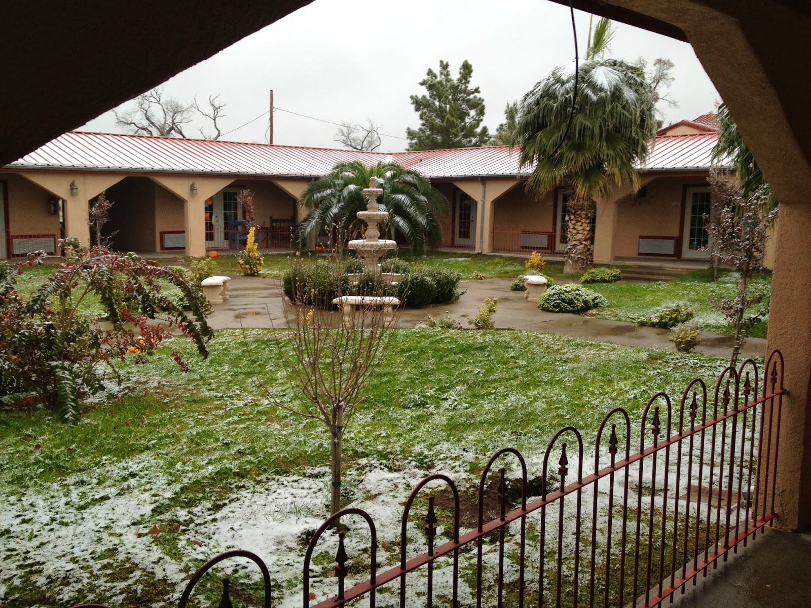
The weather for the rest of the day looks pretty bad. I don't think I'm getting out of here. Tomorrow's high is 32 and it's going to be precipitating all day. I'm thinking I will need to stay here tomorrow also. Monday's high is 47. More on this later. Right now, I want to show you the view from my room.
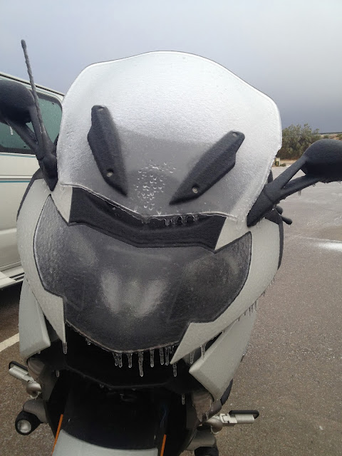
and a pic of my bike as it is now. Yes, there's about 2 mm of ice coating it.
The radar looks like this:
I'll wait out that little snow storm to my East before moving. I'm really pleased to see no other precipitation on the radar between here and Eastern Texas along I-10. With any luck, the roads will be dry all the way through Teas. Today's destination is Crowley LA. If I make it that far, the rest of the trip will be dry. Let's hope for that!
Time to use the downtime this morning to get breakfast and pack.
…
Well, I've take this as far as I can. I-10 is shutdown and I'm stuck in Sierra Blanca. Fortunately, I have a motel room. Here's my progress so far.
When I got up this morning, I saw this:
Seriously, it wast 34 degrees with 40mph winds and snow. The pavement was wet, not frozen. I suspect the ground temperature was still above freezing. I took it slow and headed down the interstate. I just wanted to get out of the "Land of Enchantment."
I came to realize that the sound of rain on the helmet has a different sound than the sound of sleet pelting the helmet. Sleet has a more tympanic sound to it. The human ear is remarkable; because even with the 40 mph wind bashing my helmet from the left and the 70mph wind from the front; both sounding like a freight train, I was able to appreciate the difference.
As it worked out, about 33 miles outside Sierra Blanco, I was low on gas and the gauge said I had 25 miles left in the tank. I was 33 miles from the nearest gas station. I know when the tank reads zero, I have another gallon. No worries, right? Wrong.
About 10 miles West of Sierra Blanca, traffic came to a stop. I was concerned now because the GPS said 15 miles to the gas station, and my distance to empty was now 8 miles. The temp was 32, and all of a sudden, it was sleeting. If I ran out of gas, I was in big trouble. For the first time, I grabbed the shoulder and rode past it all. Then I found out that the border patrol was making everyone exit the Interstate due to a 4 truck pileup…or was it 4 pileups? It seems like everyone has a different story about exactly what occurred. Either way, my DTE is now zero, and has been for the last couple miles. I was worried that the road ahead was going to take me on a 25 mile desert detour, so I asked the border patrol and was assured there were gas stations about a mile off the exit. After another 15 minutes of sitting in traffic, I made the gas station. By then, I was seeing trucks and cars plowing ice in front of their tires. Thinking about Bill Engval - "Here's your sign!," I grabbed a bite to eat and found a motel in town.
The motel is primitive; but, clean. The heat works and there's Internet and cable. No cell service.
The weather for the rest of the day looks pretty bad. I don't think I'm getting out of here. Tomorrow's high is 32 and it's going to be precipitating all day. I'm thinking I will need to stay here tomorrow also. Monday's high is 47. More on this later. Right now, I want to show you the view from my room.
and a pic of my bike as it is now. Yes, there's about 2 mm of ice coating it.

Friday, November 22, 2013
11/22/2013 Day 1: Redlands, CA to: Lordsburg, NM (579 miles)
Weather decisions made easy - Should I leave tonight and get as far as Phoenix, or should I leave in the morning; either way, trying to make Fort Stockton Texas by Saturday night?
The answer is in this one weather map:
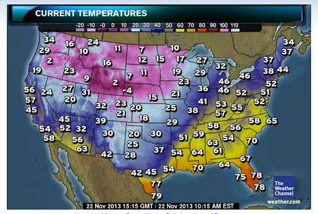
This map will stay mostly the same through Sunday, except that the 28 you see in Midland Texas will start creeping south. That said, my route from New Mexico through San Antonio is in jeopardy, with icy roads possible.
So, It seems like a better plan to attack that area of the country during daylite when the highest temps are possible. That means leaving tonight and pushing as far East as possible; Phoenix is good, Tuscon is better. With any luck, I won't have rain and freezing temperatures at the same time in Texas. Once I get through West Texas, it appears that I'll have dry roads; but, the 50's and 60's you see in this map turn to 20's and 30's. I can deal with that.
Even if I have to wait for a weather window, I'm better off doing it closer to the problem than in California, where it will take me hours to reach the area in question.
Into the rain I go!
You can watch my progress here:
http://share.findmespot.com/shared/faces/viewspots.jsp?glId=0Nh80LLnaj95s6rkXyLROojXqIlkmh6jn
…
I'm 575 miles into this trip now. It's been rain pretty much the entire time. I got a phone call from a good friend of mine and he kept me talking for an hour enabling me to make Lordsburg, New Mexico. When I came through Tuscon, they said don't go up on the mountain. Well, I didn't listen to the locals. Everything was calm until I got to about 4,000', then all hell broke loose. It's not raining as much as it was earlier today and it's not cold - 43 degrees. It's WINDY. Winds are blowing ESE 31 with gusts to 40-45. I was holding 0-15 degrees of lean most of the way up the mountain and I think my tires will have uneven wear on the right side. The sound of the wind sounds like a freight train going through my helmet.
I plan to get up at 6 and check the weather. If it's above freezing I plan to move on. If I make it to San Antonio, I should be in good shape for the rest of the trip. If I don't, I may be stranded in Texas until this storm passes through.
Wish me luck!
…
Now that I have some downtime, I can write a little more. It seems that California was doing it's best to make sure I stayed. Yesterday, nothing seemed to be working out. The forecast was horrible for the weekend and CA was rainy and windy. Never a good start to a trip. When I got home from work to pack, I parked outside my apartment like I normally do. It's on an incline and the bike stands pretty straight up because of that. Well, yesterday, I got no more than 20' from my bike and a gust of wind took it right over. I have damage (scratches and gouges only) to the right side of the bike. It went over hard. I'll post pictures. Fortunately, no mechanical damage.
I was telling my friend Jeff, who has been really great in keeping in touch with me this ride, about it and he thought a new paint job in the form of a shark with aggressive teeth would look good. Since my bike already has a natural transformers type look to it, I have no doubt I could incorporate both.
Something to think about; who's got a BMW K1600GT that looks like a high tech shark? It's a pretty awesome thought?
Jeff, Chris, Dad - Thank you all for keeping me company on this trip. It makes the miles go by very fast.
The answer is in this one weather map:
This map will stay mostly the same through Sunday, except that the 28 you see in Midland Texas will start creeping south. That said, my route from New Mexico through San Antonio is in jeopardy, with icy roads possible.
So, It seems like a better plan to attack that area of the country during daylite when the highest temps are possible. That means leaving tonight and pushing as far East as possible; Phoenix is good, Tuscon is better. With any luck, I won't have rain and freezing temperatures at the same time in Texas. Once I get through West Texas, it appears that I'll have dry roads; but, the 50's and 60's you see in this map turn to 20's and 30's. I can deal with that.
Even if I have to wait for a weather window, I'm better off doing it closer to the problem than in California, where it will take me hours to reach the area in question.
Into the rain I go!
You can watch my progress here:
http://share.findmespot.com/shared/faces/viewspots.jsp?glId=0Nh80LLnaj95s6rkXyLROojXqIlkmh6jn
…
I'm 575 miles into this trip now. It's been rain pretty much the entire time. I got a phone call from a good friend of mine and he kept me talking for an hour enabling me to make Lordsburg, New Mexico. When I came through Tuscon, they said don't go up on the mountain. Well, I didn't listen to the locals. Everything was calm until I got to about 4,000', then all hell broke loose. It's not raining as much as it was earlier today and it's not cold - 43 degrees. It's WINDY. Winds are blowing ESE 31 with gusts to 40-45. I was holding 0-15 degrees of lean most of the way up the mountain and I think my tires will have uneven wear on the right side. The sound of the wind sounds like a freight train going through my helmet.
I plan to get up at 6 and check the weather. If it's above freezing I plan to move on. If I make it to San Antonio, I should be in good shape for the rest of the trip. If I don't, I may be stranded in Texas until this storm passes through.
Wish me luck!
…
Now that I have some downtime, I can write a little more. It seems that California was doing it's best to make sure I stayed. Yesterday, nothing seemed to be working out. The forecast was horrible for the weekend and CA was rainy and windy. Never a good start to a trip. When I got home from work to pack, I parked outside my apartment like I normally do. It's on an incline and the bike stands pretty straight up because of that. Well, yesterday, I got no more than 20' from my bike and a gust of wind took it right over. I have damage (scratches and gouges only) to the right side of the bike. It went over hard. I'll post pictures. Fortunately, no mechanical damage.
I was telling my friend Jeff, who has been really great in keeping in touch with me this ride, about it and he thought a new paint job in the form of a shark with aggressive teeth would look good. Since my bike already has a natural transformers type look to it, I have no doubt I could incorporate both.
Something to think about; who's got a BMW K1600GT that looks like a high tech shark? It's a pretty awesome thought?
Jeff, Chris, Dad - Thank you all for keeping me company on this trip. It makes the miles go by very fast.
Wednesday, November 20, 2013
11/20/2013 Paul ties a gremlin bell on my ride
Today, my friend Paul, who I've done 2 long distance trips with tied a gremlin bell on my ride. Paul is a very skilled rider who has probably ridden a couple million miles in his day. He knows how to drive; but, he chooses his BMW LT 1200 over a car every time. So, it's an honor to have Paul tie my bell on. If you don't know the story, here it is, cut from the pages of www.gremlinbells.com.
<<<snip>>>
Have
you noticed that some riders have a small bell hanging off their motorcycle
frame or handlebars?
Have you wondered what the purpose is? That little bell is more than decoration, it serves a very important
purpose – it wards off gremlins, also known as evil road spirits.
You see, there are motorcycle gremlins that LOVE to ride, but they are also mischievous little devils and they cause all sorts of problems for you while you are riding. Some say they are responsible for that old lady in the minivan not seeing you and cutting you off in traffic. Or, you may be having trouble shifting smoothly, your battery goes dead, your turn signal suddenly refuses to work, an oil spill appears out of nowhere, you hit a patch of black ice, etc – you get the idea. Those little gremlins look for trouble and try to steer your bike towards it.Now, once you get a bell on your scoot – it wards off these attacks from the little gremlins, not allowing any more to get onto your bike. If you already have some gremlins riding with you, they will get trapped in the hollow of the bell, and the constant ringing will drive them insane – causing them to lose their grip and fall to the roadway.Do you have the protection of a gremlin bell?
<<<snip>>>
Sunday, November 17, 2013
11/22 - 11/25 CA to PA Planning
I have settled on a plan to get from California to Pennsylvania. The route I want to take is just better than 3,000 miles, and if I can do it in 72 hours, I will get another Iron Butt certification. Here's the mileage table…

The actual trip is about 3100 miles. On the last leg, I'll either stop before my destination to get my affidavit signed, or, if I can make it within the timeframe, get it signed at my final destination.
The good news is that this gets me to my destination during daylight. This is important because there is the possibility of snow and ice. I'd like to be off the road on my final day before the sun is down. This plan makes it possible; but doesn't give me much contingency time. Whatever contingency time I do get will be from traveling more than 60 miles per hour and sleeping less than 8 hours a day. This route also keeps me in the South, where it's warmer, for as long as possible.
Game on!!!
Saturday, November 16, 2013
11/16/2013 - Yosemite (Pictures)
6 AM local time and of course, I'm wide awake. It's 29 degrees outside, with a high forecast of 55. Wind will pick up in the afternoon to 11 MPH; but, for the morning, they are going to be pretty tame, so wind chill should be pretty tame. We're only going to cover 200 and some miles, so we're planning lots of stops to photograph the fire damage and the beautiful areas of the park. Tonight's stop will be in Bakersfield, making for a pretty short ride home on Sunday.

My spot failed me a little today. We didn't really go from point 47 to point 48 on this map in 10 minutes. Actual time was about 2 hours. I think the tree canopy may have stopped Spot from talking to the satellite. Also, we started at point 30 today. Here's a better map of today's travels…

Rt. 49 out of Mariposa is outstanding. The road is new blacktop, newly lined, with a very consistent surface. I don't think we experienced a single bump the entire time. The curves are fantastic; though, many of them are blind and require lots of attention to your speed and line.
Our first stop in the park was at some fire damaged areas. It's unsettling and pictures can't describe how bad it is. Here's a map of the fire damaged areas…
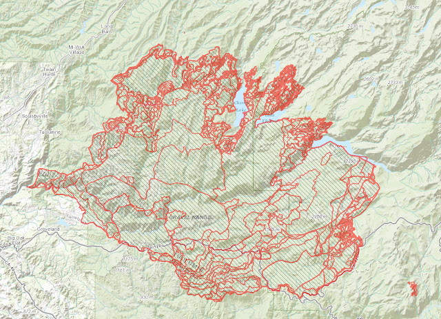
I don't have any sponsors; but my friend Paul works for ESRI, a Geographic Information Services (GIS) company. He made this map using their arcgis web tool. www.arcgis.com This is the same tool that the firefighters were using and populating data into. During this fire, firefighters were flying over this fire collecting data, infrared and otherwise, and populating this tool. Behind this map and each little perimeter is a series of data. You can click through this map on arcgis server and see all that data. It's an incredibly powerful tool. Thanks Paul for taking the time to show me all this.
If you happened to be asleep in July, when the fire started, here's what you missed…
And finally, some of today's pictures…


My spot failed me a little today. We didn't really go from point 47 to point 48 on this map in 10 minutes. Actual time was about 2 hours. I think the tree canopy may have stopped Spot from talking to the satellite. Also, we started at point 30 today. Here's a better map of today's travels…
Rt. 49 out of Mariposa is outstanding. The road is new blacktop, newly lined, with a very consistent surface. I don't think we experienced a single bump the entire time. The curves are fantastic; though, many of them are blind and require lots of attention to your speed and line.
Our first stop in the park was at some fire damaged areas. It's unsettling and pictures can't describe how bad it is. Here's a map of the fire damaged areas…
I don't have any sponsors; but my friend Paul works for ESRI, a Geographic Information Services (GIS) company. He made this map using their arcgis web tool. www.arcgis.com This is the same tool that the firefighters were using and populating data into. During this fire, firefighters were flying over this fire collecting data, infrared and otherwise, and populating this tool. Behind this map and each little perimeter is a series of data. You can click through this map on arcgis server and see all that data. It's an incredibly powerful tool. Thanks Paul for taking the time to show me all this.
If you happened to be asleep in July, when the fire started, here's what you missed…
And finally, some of today's pictures…


Subscribe to:
Posts (Atom)